Topographic maps for Garmin GPS handhelds
MD5 checksum: cd164227dfb0528a928afc2b0f6a2d40
The zip archive contains a file "gmapsupp.img". This is a map file compatible with many GPS receivers made by Garmin.
Usage:
Unzip the file and copy the "gmapsupp.img" file to your GPS unit into the "Garmin" subdirectory. You can use an USB cable with the unit in mass storage mode or copy it directly onto the storage card using a card reader. The latter is probably faster.
Your GPS unit must have 1 GB memory or more. The map won't work on units with little memory like the Vista HC (24 MB, no card slot).
The map was tested using a Garmin eTrex Legend HCx.
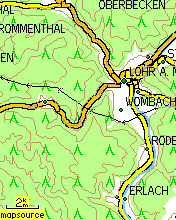
Here you can see the coverage of the map tiles.
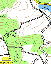
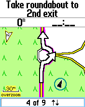
A few screenshots:
|
|
|
|
|
|
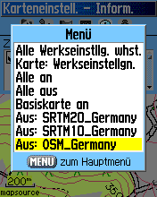
The contour lines are in two separate transparent overlay maps. One ('SRTM20_Germany') contains one contour line every 20 m. This should be good for not overloading the map in mountainous regions. The other one ('SRTM10_Germany') contains additional minor contour lines every 10 m. This is for enhanced precision in flat areas. You can easily switch the layers on and off in the GPS menu (see screenshot 3).
The map supports routing. i.e. the "follow road" option in the GPS menu. This feature is still experimental and not everything is fully implemented yet. See the mkgmap development page for details.
If you want to use my maps with Garmin Mapsource you can split the gmapsupp.img with wgmaptool (get it here) (Use the GUI or run "gmt.exe -S -f 1331 gmapsupp.img"). Then copy the overview map into the destination directory and run "install.bat". The SRTM layers will not be included because they have a different family ID.
Here is another tutorial for importing mkgmap generated maps into Mapsource.
NEW: I rebuilt the SRTM layers in with the latest version of Srtm2OSM and the mkgmap splitter so there should be fewer bugs. For example the old bug that the splitter didn't support ways which are in more than 4 tiles is solved.
The map was made with mkgmap version r1065.
There is no guarantee of completeness, accuracy of any kind or fitness for any purpose.
For everyone who wants to make such a map themselves: Here is a small HOWTO instruction on my map making process.
These maps were created using map data from www.openstreetmap.org and height data from SRTM. The license of the map data and therefore the license of the OSM component of the maps is the Creative Commons Attribution-ShareAlike 2.0.